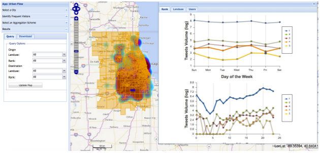
Every day massive amounts of geo-tagged information are generated around the urban environment using Micro-blog data services and content sharing platforms. These new Big Geospatial Data sources provide an opportunity to understand people activities and their interaction with the urban environment. In this regard, it is crucial to integrate geo-tagged micro-data with more authoritative sources such as official land-use maps. Such integration would benefit the urban research community by combining real-time information about people activities and their spatial interaction with the synoptic view of physical infrastructure as depicted in official land-use maps.
UrbanFlow is a platform to integrate geolocated Twitter data with detailed land-use map (parcel level) to detect and analyze individual human mobility patterns. The platform provides scientists with a set of tools to extract key locations of each Twitter user, assess the extraction quality and uncertainty, and analyze city neighbors’ connectivity based on detected users’ frequent visitation patterns. These capabilities are built on a novel scalable solution for the point in/nearest polygon algorithm, implemented on Hadoop to harness the power of distributed systems to combine massive point data and a large number of the polygon in scale-out fashion.
NSF Grant Numbers: 1047916, 1354329, 1443080, 1429699.
People: Kiumars Soltani (soltani2@illinois.edu), Aiman Soliman (asoliman@illinois.edu), Anand Padmanabhan (apadmana@illinois.edu), Shaowen Wang (shaowen@illinois.edu)

Publications:
- Social sensing of urban land use based on analysis of Twitter users mobility patterns Soliman, A., Soltani, K., Yin, J., Padmanabhan, A. and Wang, S., 2017, PLoS One.
- Soltani, K., Soliman, A., Padmanabhan, A., and Wang, S. 2016. “UrbanFlow: Large-scale Framework to Integrate Social Media and Authoritative Landuse Maps.” Proceedings of the 2016 Annual Conference on Extreme Science and Engineering Discovery Environment (XSEDE’16). July 17-21. Miami, Florida.
- Soliman, A., Yin, J., Soltani, K., Padmanabhan, A., and Wang, S. 2015. “Where Chicagoans tweet the most: Semantic analysis of preferential return locations of Twitter users.” Proceedings of the First ACM SIGSPATIAL International Workshop on Smart Cities and Urban Analytics (UrbanGIS’15).
External Links: Science Node Magazine Coverage on UrbanFlow: Hearing the heartbeat of a city.


