CyberGIS-HydroShare


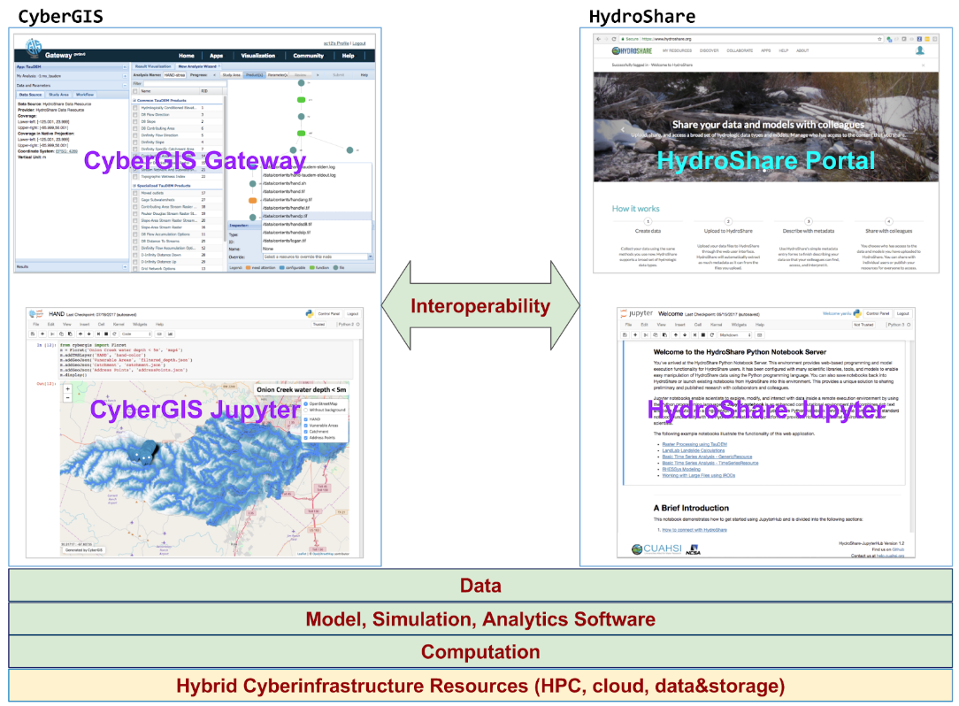
HydroShare is a collaborative environment for sharing hydrologic data and models.  It primarily serves the hydrologic sciences community. Both CyberGIS and HydroShare are sustainable software integration projects following open and adaptable software development practices. Both projects move computation off the desktop into advanced cyberinfrastructure based on service-oriented architecture enabling computation on big data, avoiding platform dependency and software installation requirements and serving as gateways to high performance computing. Interoperability between the two systems will enable the coupling of data and multi-scale and multidisciplinary modeling capabilities from both communities and empower scalable geospatial and hydrologic sciences. As both projects grow to integrate big data analytics and advanced modeling capabilities, we face two major challenges in interoperability that we believe XSEDE can help address with its richness in cyberinfrastructure resources and supercomputing architecture:

  1. How to establish a user environment that seamlessly integrates distributed data, software, and computation from both CyberGIS and HydroShare in a sandbox where users can focus on domain research?
  2. How to achieve interoperability features as extensible, reproducible, and reusable software solutions for scalable development, deployment, and operation in order to support broader collaboration of various multidisciplinary research in our communities?

Grant: NSF award 1047916

People: Anand Padmanabhan (apadmana@illinois.edu), Dandong Yin (dyin4@illinois.edu), Fangzheng Lyu(flu8@illinois.edu), Shaowen Wang (shaowen@illinois.edu)


External Link:  Hydroshare Project

Computational Movement Pattern Analysis


The analysis of geographic mobility data and associated spatial interactions is of great importance to understanding complex geographic phenomena and their space-time dynamics.

This research project aims to design and develop innovative data models and analytical methods for data-intensive movement analysis. Statistical and computational approaches are developed to study spatial patterns of origin-destination movement flows and more generally spatial interactions. Specifically, a multidimensional spatial point data model has been developed, which models each OD movement flow as a point with four spatial dimensions, two for its origin and two for its destination. It is then possible to detect spatial movement patterns by analyzing the 4D point patterns, using methods such as scan statistics. For instance, with a bivariate 4D point process model, we can evaluate the differences and similarities between the spatial distributions of a pair of OD movement datasets, and detect areas where the two spatial distributions differ the most. A multidimensional Bernoulli spatial scan statistics method is developed to detect OD region pairs with abnormally high concentrations of one movement dataset over the other. Experiments demonstrate that our method can effectively detect spatial patterns from large movement datasets, and is applicable to both individual-level and aggregated movement data.

People: Yizhao Gao (ygao29@illinois.edu), Ting Li (tingli3@illinois.edu), Shaowen Wang (shaowen@illinois.edu), Myeong-Hun Jeong (mhjeong@myeonghun.org), Kiumars Soltani (soltani2@illinois.edu)


Publications:

  • Yizhao Gao, Ting Li, Shaowen Wang, Myeong-Hun Jeong & Kiumars Soltani (2018) “A multidimensional spatial scan statistics approach to movement pattern comparison”. International Journal of Geographical Information Science. 32:7, 1304-1325, DOI: https://doi.org/10.1080/13658816.2018.1426859