ViCTS is a novel network partition algorithm for scalable agent-based modeling of mass evacuation. VICTS is based on a cyberGIS-enabled computational framework for exploiting unique spatial movement patterns of an emergency evacuation. Experiments show that our algorithm outperforms a popular network partition algorithm for microscopic traffic simulation in terms of load-balancing and communication reduction. Furthermore, the entire computational environment and software codes of this framework are built into a Docker image with a series of Jupyter notebooks, which enables the reproducibility, validation and future extension of the framework by broad cyberGIS and spatial modeling communities.
Every day massive amounts of geo-tagged information are generated around the urban environment using Micro-blog data services and content sharing platforms. These new Big Geospatial Data sources provide an opportunity to understand people activities and their interaction with the urban environment. In this regard, it is crucial to integrate geo-tagged micro-data with more authoritative sources such as official land-use maps. Such integration would benefit the urban research community by combining real-time information about people activities and their spatial interaction with the synoptic view of physical infrastructure as depicted in official land-use maps.
UrbanFlow is a platform to integrate geolocated Twitter data with detailed land-use map (parcel level) to detect and analyze individual human mobility patterns. The platform provides scientists with a set of tools to extract key locations of each Twitter user, assess the extraction quality and uncertainty, and analyze city neighbors’ connectivity based on detected users’ frequent visitation patterns. These capabilities are built on a novel scalable solution for the point in/nearest polygon algorithm, implemented on Hadoop to harness the power of distributed systems to combine massive point data and a large number of the polygon in scale-out fashion.
NSF Grant Numbers: 1047916, 1354329, 1443080, 1429699.
Social sensing of urban land use based on analysis of Twitter users mobility patterns Soliman, A., Soltani, K., Yin, J., Padmanabhan, A. and Wang, S., 2017, PLoS One.
Soltani, K., Soliman, A., Padmanabhan, A., and Wang, S. 2016. “UrbanFlow: Large-scale Framework to Integrate Social Media and Authoritative Landuse Maps.” Proceedings of the 2016 Annual Conference on Extreme Science and Engineering Discovery Environment (XSEDE’16). July 17-21. Miami, Florida.
Soliman, A., Yin, J., Soltani, K., Padmanabhan, A., and Wang, S. 2015. “Where Chicagoans tweet the most: Semantic analysis of preferential return locations of Twitter users.” Proceedings of the First ACM SIGSPATIAL International Workshop on Smart Cities and Urban Analytics (UrbanGIS’15).
TopoLens is a cyberGIS app for delivering community data services developed for easy and efficient access to high-resolution topographic data. The app supports on-demand data and map services, powered by hybrid cyberinfrastructure with cloud and HPC support, to efficiently produce datasets that are customized based on user’s request. Currently, TopoLens has precomputed Digital Elevation model (DEM), slope and shaded relief data products at the state level (48 contiguous states and the District of Columbia) and at watershed region level (18 HUC2 Hydrologic Units) in the US, with 51 different map projections.
Grant Numbers: USGS (G14AC00244), NSF (1047916, 1443080, 1429699)
Hu, H., Yin, D., Liu, Y.Y., Terstriep, J., Hong, X., Wendel, J., and Wang, S. (2018) TopoLens: Building A CyberGIS Community Data Service for Enhancing the Usability of High-resolution National Topographic Datasets. Concurrency and Computation: Practice and Experience, accepted
Hu, H., Hong, X., Terstriep, J., Liu, Y.Y., Finn, M.P., Rush, J., Wendel, J. and Wang, S., 2016, July. TopoLens: Building a CyberGIS Community Data Service for Enhancing the Usability of High-resolution National Topographic Datasets. In Proceedings of the XSEDE16 Conference on Diversity, Big Data, and Science at Scale (p. 39). ACM.
The Resource Management Mapping Service (RMMS) utilizes a wide range of coordinated natural resource-related databases to provide an online, interactive mapping environment that is designed to help government agencies, non-governmental organizations, and the public evaluate and manage geographically-based information about Illinois’ natural resources, particularly water resources, so that they can more effectively develop and implement appropriate resource protection and enhancement measures. The RMMS website also contains tools (requiring a login/password for access) for direct data entry of specific databases. These databases are only available at the RMMS website. Specific Illinois Environmental Protection Agency (IEPA) layers are available for extraction and download. Continuing development of RMMS is provided at the University of Illinois CIGI Lab with support from the IEPA and other state agencies as well as match funds from the University of Illinois.
Geographic Information Systems (GIS) have gone through rapid growth since originally developed in the 1960s. In the foreseeable future, GIS software will continue to play essential roles for breaking through scientific challenges in numerous fields and improving decision-making practices with broad societal impacts. However, fulfilling such roles is increasingly dependent on the ability to handle very large spatiotemporal data sets and complex analysis software based on synthesizing computational and spatial thinking enabled by cyberinfrastructure, which conventional GIS-based software approaches do not provide. This project will establish CyberGIS as a fundamentally new software framework comprising a seamless integration of cyberinfrastructure, GIS, and spatial analysis/modeling capabilities.
Project objectives:
Engage multidisciplinary communities through a participatory approach to evolving CyberGIS software requirements
Integrate and sustain a core set of composable, interoperable, manageable, and reusable CyberGIS software elements based on community-driven and open source strategies
Empower high-performance and scalable CyberGIS by exploiting spatial characteristics of data and analytical operations for achieving unprecedented capabilities for geospatial scientific discoveries
Enhance an online geospatial problem-solving environment to allow for the contribution, sharing and learning of CyberGIS software by numerous users, which will foster the development of crosscutting education, outreach and training programs with significant broad impacts
Deploy and test CyberGIS software by linking with national and international CI to achieve scalability to significant sizes of geospatial problems, amounts of CI resources, and number of users
Evaluate and improve the CyberGIS framework through domain science applications and vibrant partnerships to gain the better understanding of the complexity of coupled human-natural systems (e.g. for assessing impacts of climate change and rapid emergency response).
Massive spatial data collected from numerous sources are increasingly used to instrument our natural, human and social systems at unprecedented scales while providing us with tremendous opportunities to gain dynamic insight into complex phenomena. Though such big data streams play crucial roles in many scientific domains and promise to enable a wide range of decision-making practices with significant societal impacts, exploiting them successfully poses significant challenges. On one hand, spatial and location attributes serve as a common key to many types of data such as census and population, land use and cover, floodplain, and vegetation distribution. Oftentimes perceived as significant benefits, spatial data synthesis can be used to link disparate pieces of data that pertain to common spatial references and units. On the other hand, however, there are diverse spatial references and units for data collection and management and they are based on different representation models and assumptions.
To break through these challenges, this project aims to establish a suite of scalable capabilities for spatial data synthesis enabled by innovative cloud computing and cyberGIS and driven by multiple scientific communities. Such capabilities will also be designed to support integration with cyberGIS analytics and workflow for solving scientific problems. The project establishes core capabilities through a spiral approach by initially developing the capabilities for solving specific scientific problems and later moving on to engage broader communities for validating and improving the core capabilities. The scientific problems will revolve around two interrelated themes: 1) measuring urban sustainability based on a number of social, environmental, and physical factors and processes; and 2) examining population dynamics by synthesizing multiple states of the art population data sources with social media data.
Hu, H., Lin, T., Wang, S., and Rodriguez, L.F. “A cyberGIS approach to uncertainty and sensitivity analysis in biomass supply chain optimization,” Applied Energy, v.203, 2017, p. 26–40. doi:https://doi.org/10.1016/j.apenergy.2017.03.107
Wang, S. “CyberGIS and spatial data science,” GeoJournal, v.81, 2016, p. 965–968.
Armstrong, M.P., Wang, S. and Zhang, Z. (2018) “The Internet of Things and Fast Data Streams: Prospects for Geospatial Data Science in Emerging Information Ecosystems”. In: M. Freundschuh and D. Sinton (Eds.), Frontiers of Geospatial Data Science. Conference Proceedings, AutoCarto/UCGIS 2018, the 22nd International Research Symposium on Computer-based Cartography and GIScience (pp. 11-17)
Armstrong, M. P., Wang, S., and Zhang, Z. (2019) “The Internet of Things and fast data streams: prospects for geospatial data science in emerging information ecosystems”. Cartography and Geographic Information Science, 46(1), 39-56.
Feng, L., Kate, K., Pierre, R., and Jon, W. “Dynamically Negotiating Capacity Between On-demand and Batch Clusters.” In: Proceedings of the Supercomputing’17 Conference. 2017.
Gao, Y., Li, T., Wang, S., Jeong, M., and Soltani, K. (2018) “A Multidimensional Spatial Scan Statistics Approach to Movement Pattern Comparison”. International Journal of Geographical Information Science (IJGIS), 32(7): 1304-1325
Gao, Y., Wang, S., Padmanabhan, A., Yin, J., and Cao, G. (2018) “Mapping Spatiotemporal Patterns of Events Using Social Media: A Case Study of Influenza Trends”. International Journal of Geographical Information Science (IJGIS), 32(3), 425-449
Hu, H., Lin, T., Wang, S., and Rodriguez, L. 2017. “A CyberGIS Approach to Uncertainty and Sensitivity Analysis in Biomass Supply Chain Optimization”. Applied Energy, 203, 26-40. DOI: https://doi.org/10.1016/j.apenergy.2017.03.107
Hu, H., Yin, D., Liu, Y. Y., Terstriep, J., Hong, X., Wendel, J., and Wang, S. (2018) “TopoLens: Building a CyberGIS Community Data Service for Enhancing the Usability of High-resolution National Topographic Datasets”. Concurrency and Computation: Practice and Experience, DOI: https://doi.org/10.1002/cpe.4682
Jeong, M.-H., Cai, Y., Sullivan, C. J., and Wang, S. (2016). “Data depth based clustering analysis”. In: Proceedings of the 24th ACM SIGSPATIAL International Conference on Advances in Geographic Information Systems (ACM SIGSPATIAL 2016), October 31 – Thursday, November 3, 2016 — San Francisco Bay Area, California, USA.
Jeong, M., Yin, J., and Wang, S. (2018) “Outliers Detection and Comparison of Origin-Destination Flows with Data Depth”. In: Proceedings of the 10th International Conference on Geographic Information Science (GIScience 2018), August 28 – 31, 2018, Melbourne, Australia
Keahey K., Riteau P. and Timkovich N. (2017). “LambdaLink: an Operation Management Platform for Multi-Cloud Environment”. In: Proceedings of the 10th International Conference on Utility and Cloud Computing, pp. 39-46. ACM, 2017.
Lin, T., Wang, S., Rodríguez, L. F., Hu, H., and Liu, Y.Y. “CyberGIS-Enabled Decision Support Platform for Biomass Supply Chain Optimization,” Environmental Modelling & Software, 2015.
Qiaobin, F., Timkovich, N., Riteau, P., and Keahey K. (2018) “A Step towards Hadoop Dynamic Scaling”. In: The 20th IEEE International Conference on High-Performance Computing and Communications (HPCC-2018), Exeter, United Kingdom. June 2018
Soliman, A., Soltani, K., Yin, J., Padmanabhan, A., and Wang, S. (2017). “Social sensing of urban land use based on analysis of Twitter users’ mobility patterns”. PLos One, 12(7). DOI: https://doi.org/10.1371/journal.pone.0181657
Soliman, A., Yin, J., Soltani, K., Padmanabhan, A., and Wang, S. 2015. “Where Chicagoans tweet the most: Semantic analysis of preferential return locations of Twitter users”. Proceedings of the First ACM SIGSPATIAL International Workshop on Smart Cities and Urban Analytics (UrbanGIS’15).
Soltani, K., Soliman, A., Padmanabhan, A., and Wang, S. 2016. “UrbanFlow: Large-scale Framework to Integrate Social Media and Authoritative Landuse Maps”. Proceedings of the 2016 Annual Conference on Extreme Science and Engineering Discovery Environment (XSEDE’16). July 17-21. Miami, Florida.
Wang, S., Hu, H., Lin, T., Liu, Y., Padmanabhan, A., and Soltani, K. “CyberGIS for Data-Intensive Knowledge Discovery,” ACM SIGSPATIAL Newsletter, 2014.
Wang, S., Liu, Y., and Padmanabhan, A.. “Open CyberGIS Software for Geospatial Research and Education in the Big Data Era,” SoftwareX, 2015. DOI: https://doi.org/10.1016/j.softx.2015.10.003
Xu, Z., Guan, K., Casler, N., Peng, B., and Wang, S. (2018) “A 3D Convolutional Neural Network Method for Land Cover Classification Using LiDAR and Multi-Temporal Landsat Imagery”. ISPRS Journal of Photogrammetry and Remote Sensing, accepted
Yin, D., Liu, Y., Padmanabhan, A., Terstriep, J., Rush, J., and Wang, S. (2017). “A CyberGIS-Jupyter Framework for Geospatial Analytics at Scale”. In: Proceedings of the 2017 Practice & Experience in Advanced Research Computing (PEARC’17). July 9–13. New Orleans, LA.
Yin, J., Soliman, A., Yin, D, and Wang, S. (2017). “Depicting Urban Boundaries from a Mobility Network of Spatial Interactions: A Case Study of Great Britain with Geo-located Twitter Data”. International Journal of Geographical Information Science DOI: https://doi.org/10.1080/13658816.2017.1282615
Zhang, Z., Demšar, U., Wang, S., and Virrantaus, K. (2018) “A Spatial Fuzzy Influence Diagram for Modelling Spatial Objects’ Dependencies: A Case Study on Tree-related Electric Outages”. International Journal of Geographical Information Science (IJGIS), 32(2): 349-366
Terra is the flagship of NASA’s Earth Observing System. Its datasets are amongst the most popular NASA datasets, serving not only the scientific community, but also governmental, commercial, and educational communities. The strength of the Terra mission has always been rooted in its five instruments and the ability to fuse the instrument data together for obtaining the greater quality of information for Earth Science compared to individual instruments alone. This project aims to efficiently generate and deliver Terra data fusion products, and facilitate the use of Terra data fusion products by the community.
Our approach leverages national facilities and services that are managed by the National Center for Supercomputing Applications, specifically the National Petascale Computing Facility, which houses the Blue Waters supercomputer, and the National Data Service (NDS). Key advantages of leveraging Blue Waters and the NDS for access, usage, and distribution of Terra data fusion products and science results are that the Terra data and processing are local, with access and sharing that are global. This represents a significant community-element addition to NASA’s system of systems infrastructure. ACCESS to Terra Data Fusion Products will initiate the development, access and delivery of Level 1B radiance Terra Fusion files for the broader community. Level 1B fusion provides the necessary stepping-stone for developing higher-level products, and provides the framework for other flavors of fusion. Enhancements to our existing open source codes in the CyberGIS Toolkit for scalable map projections on any grid for the new Terra Fusion files will also be delivered.
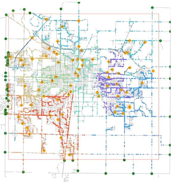
Geospatially heterogeneous and interdependent changes across the globe, such as natural disasters, environmental changes, population growth, and rapid urbanization, have posted many grand scientific and societal challenges. To tackle these challenges, as a geospatial data deluge permeates broad scientific and societal realms, requires critical thinking about the complex interactions between their driving factors and related geospatial patterns across a number of spatial and temporal scales. Geospatial software plays increasingly important roles in examining such interactions and has been widely developed and used by numerous communities to transform data with geo and spatial references into valuable insights and significant scientific knowledge. The growing benefits and importance of geospatial software to science and engineering is driven by tremendous needs in numerous fields such as agriculture, ecology, emergency management, environmental engineering and sciences, geography and spatial sciences, geosciences, national security, public health, and social sciences, to name just a few, and is reflected by a massive digital geospatial industry.
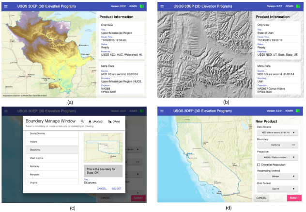
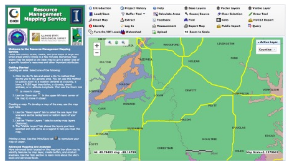
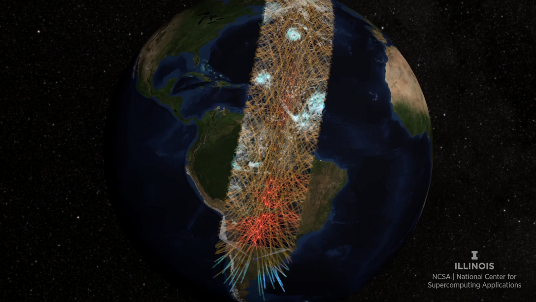
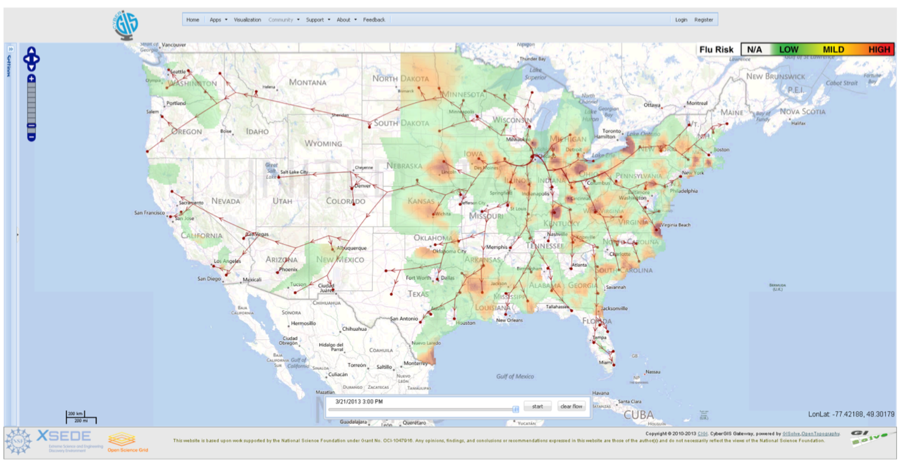
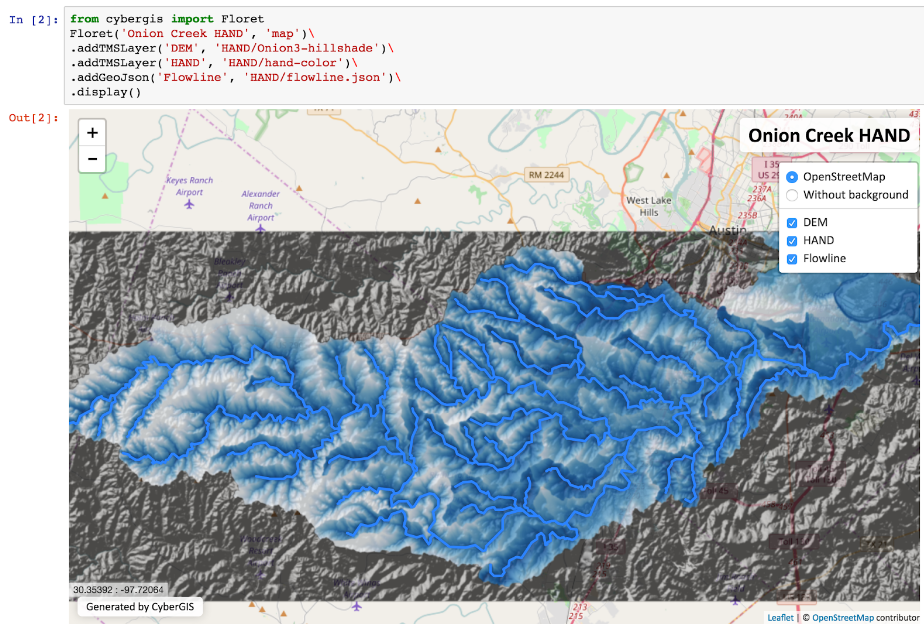
Pioneered by NSF-funded research responding to these grand challenges and needs, cyberGIS (aka cyber geographic information science and systems based on advanced computing and cyberinfrastructure (CI)) has emerged as new-generation GIS, comprising a seamless integration of advanced CI, GIS, and spatial analysis and modeling capabilities while leading to widespread research advances and broad societal impacts (Wang 2010; Wright and Wang 2011). CyberGIS has provided a solid foundation for breakthroughs in diverse science, technology and application domains, and contributed to the innovation of CI overall (Anselin and Rey 2012; Wang 2017). During the past several years, cyberGIS has grown as a vibrant interdisciplinary field as evidenced through impactful publications and number of hardware and software capabilities, collaborative projects, meetings, conferences, and workshops. For example, NSF has funded a ~$4.8 million multi-institution project: SI2-SSI: CyberGIS Software Integration for Sustained Geospatial Innovation that involves a number of academic institutions, industrial partners (e.g. Esri), U.S. government agency partners (e.g. U.S. Geological Survey (USGS)), U.S. federally funded research and development laboratories (e.g. Oak Ridge National Laboratory), and multiple international partners. With an international scope, the project has established a novel cyberGIS software framework while achieving major scientific and technological advances in tackling challenging environmental and geospatial problems (Wang et al. 2013).
This research aims to demonstrate the use of massive social media data to interactively analyze spatiotemporal events across spatial and temporal scales, by establishing a data-driven framework using cyberGIS to resolve aforementioned challenges. Specifically, FluMapper—an application on the CyberGIS Gateway—is employed as a case study to demonstrate the data-driven framework and seamless integration of massive location-based social media data and spatial analytical services within the online problem solving environment of the Gateway.
FluMapper presents integrated results from two complementary spatial analyses: (i) an interactive exploration of spatial distribution of flu risk and (ii) dynamic mapping of movement patterns, across multiple spatial, and temporal scales. The seamless integration of these two analyses through the framework illustrates the potential of cyberGIS to resolve the data- and computation-intensive challenges of analyzing near real-time social media data in an efficient and scalable manner and to support interactive visualization.
Wang, S., Cao, G., Zhang, Z., Zhao, Y., and Padmanabhan, A. 2013. “A CyberGIS Environment for Analysis of Location-Based Social Media Data.” In: Location-Based Computing and Services, 2nd Edition, ed. A. K. Hassan and H. Amin, CRC Press, pages: 187-205
Hwang, M., Wang, S., Cao, G., Padmanabhan, A., Zhang, Z. 2013. “Spatiotemporal Transformation of Social Media Geostreams: A Case Study of Twitter for Flu Risk Analysis.” In: Proceedings of the 4th ACM SIGSPATIAL International Workshop on GeoStreaming (IWGS), November 5 2013, Orlando, Florida, USA
Padmanabhan, A., Wang, S., Cao, G., Hwang, M., Zhao, Y., Zhang, Z., and Gao, Y. 2013. “FluMapper: An Interactive CyberGIS Environment for Massive Location-based Social Media Data Analysis.” In: Proceedings of XSEDE 2013: Extreme Science and Engineering Discovery Environment: Gateway to Discovery, Jul 22-25 2013, San Diego, CA, USA.
Zhang, Z., Wang, S., Cao, G., Padmanabhan, A., Wu, K. 2014. “A Scalable Approach to Extracting Mobility Patterns from Social Media Data.” In: Proceedings of the 22nd International Conference on Geoinformatics (Geoinformatics 2014), pages 1-6, IEEE Xplore Digital Library. http://ieeexplore.ieee.org/abstract/document/6950845/
Padmanabhan, A., Wang, S., Cao, G., Hwang, M., Zhang, Z., Gao, Y., Soltani, K., and Liu, Y.Y. 2014. “FluMapper: A CyberGIS Application for Interactive Analysis of Massive Location-based Social Media.” Concurrency and Computation: Practice and Experience. 26(13), 2253–2265. http://dx.doi.org/10.1002/cpe.3287
Soltani, K., Padmanabhan, A., and Wang, S. 2015. “MovePattern:Interactive framework to provide scalable visualization of movement patterns”. Proceedings of the 2015 ACM SIGSPATIAL International Workshop on Computational Transportation Science, Nov 3-6, Seattle, WA.
Cao, G., Wang, S., Hwang, M., Padmanabhan, A., Zhang, Z., and Soltani, K. 2015. “A Scalable Framework for Spatiotemporal Analysis of Location-based Social Media Data”. Computers, Environment and Urban Systems. 51, 70-82. https://doi.org/10.1016/j.compenvurbsys.2015.01.002
Helwig, N.E., Gao, Y., Wang, S. and Ma, P., 2015. Analyzing spatiotemporal trends in social media data via smoothing spline analysis of variance. Spatial Statistics, 14, pp.491-504.
Gao, Y., Wang, S., Padmanabhan, A., Yin, J. and Cao, G., 2018. Mapping spatiotemporal patterns of events using social media: a case study of influenza trends. International Journal of Geographical Information Science, 32(3), pp.425-449.
CyberGIS-Jupyter is an innovative cyberGIS framework for achieving data-intensive, reproducible, and scalable geospatial analytics using Jupyter Notebook. The framework adapts the Notebook with built-in cyberGIS capabilities to accelerate gateway application development and sharing while associated data, analytics, and workflow runtime environments are encapsulated into application packages that can be elastically reproduced through cloud computing approaches. As a desirable outcome, data-intensive and scalable geospatial analytics can be efficiently developed and improved, and seamlessly reproduced among multidisciplinary users in a novel cyberGIS science gateway environment.
Grant Numbers: NSF (1047916, 1443080, 1551492, 16644119, 1229699)
Yin, D., Liu, Y., Padmanabhan, A., Terstriep, J., Rush, J., & Wang, S. (2017, July). A CyberGIS-Jupyter Framework for Geospatial Analytics at Scale. In Proceedings of the Practice and Experience in Advanced Research Computing 2017 on Sustainability, Success and Impact (p. 18). ACM.